Heavy Rains
Douse Central and Southern Minnesota
August 20-21, 2002
A succession of heavy thunderstorms drifted
across central and southern Minnesota on August 20 and 21, leaving a
stripe of heavy rain that spanned the width of the state. The heaviest
precipitation fell upon southwestern, west central, and central
Minnesota where some rainfall totals exceeded five inches. Five inch
totals were reported in sections of Lac Qui Parle, Yellow Medicine,
Chippewa, Meeker, and Rock counties. The highest rainfall total was 6.30
inches in Montevideo. An anecdotal report of 8.30 inches came from a
location one mile east of downtown Montevideo.
 In west central and central Minnesota, the rains began during the mid-afternoon hours of August
20 and continued into the early morning of August 21. A second rain complex
formed during the morning hours of August 21 in southwestern Minnesota
and finally cleared southeastern Minnesota by late afternoon.
In west central and central Minnesota, the rains began during the mid-afternoon hours of August
20 and continued into the early morning of August 21. A second rain complex
formed during the morning hours of August 21 in southwestern Minnesota
and finally cleared southeastern Minnesota by late afternoon.
In the affected areas of west central Minnesota, a 24-hour rainfall total
of five inches is considered to be a one percent
probability occurrence. Elsewhere in southern Minnesota, a one percent
probability event is six inches in 24 hours.
In spite of the intense rainfall, relatively few problems with
urban or rural flooding were reported. In west central Minnesota,
antecedent conditions were relatively dry, meaning that soils were
receptive to the heavy rain.
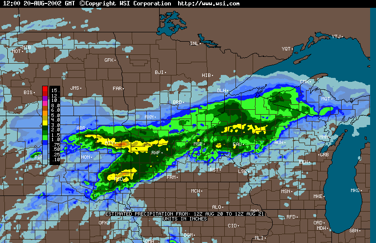
National Weather Service radar
imagery can be used to estimate precipitation totals in near real-time. A private vendor (WSI) purchases radar data from the National Weather Service and utilizes the data to prepare
the precipitation estimates offered in the hyperlinks below. Precipitation estimates from radar returns are often fraught with errors.
Attenuation from heavy rain, enhanced reflection due to hail, and
distance from the radar site, can cause radar-based estimates to over or
under estimate true precipitation totals. For these reasons, this
technology may never replace the need for ground-based precipitation
measurements.
WSI radar-based
precipitation estimate - 24 hour totals ending 7:00 AM, August 21
WSI radar-based precipitation estimate -
24 hour totals ending 7:00 AM, August 22
A labeled-line, black-and-white
Windows Metafile (wmf) version of the color map can be obtained by
right-clicking on this link
and choosing "Save Target As" or "Save Link As".
This version of the map will be useful for insertion into
documentation that requires inexpensive photo-reproduction.
A list of the 156 data points used to generate the map
is offered here. The values are x and y utm coordinates (NAD83, zone 15), followed by a 48-hour precipitation total
(August 20 and 21) in inches. The data cover the entire state of Minnesota, but the
majority of the entries are from the southern half of Minnesota.
The State Climatology Office thanks
Soil and Water Conservation Districts in the affected areas for their
prompt and thorough response to our request for precipitation data.
Data were also provided by the National Weather
Service. We thank Minnesota's many volunteer precipitation monitors, whose
diligent efforts make detailed analysis of storm events possible.

 Return to the Climate Journal Return to the Climate Journal
mcwg@soils.umn.edu
URL:
http://climate.umn.edu/doc/journal/flash_floods/ff020820-21.htm
Last modified: August 22, 2002
|