Heavy Rains
Drench Portions of Marshall County
August 27-28, 2002
Heavy rain produced by slow moving thunderstorms
deposited five to six inches of rain onto portions of western Marshall
county during the evening hours of Tuesday, August 27 and the
early morning hours of Wednesday, August 28. This was in addition
to approximately one inch of rain that had fallen just 24 hours earlier
during the afternoon and evening of Monday, August 26. The highest
reported 24-hour rainfall total for the August 27-28 storm was 5.61
inches at Argyle. Rainfall totals exceeded four inches in a 10 mile
wide band dissecting Marshall county from the Red River to
just east of Argyle. Widespread agricultural flooding was reported.
Other communities in northwestern Minnesota received heavy,
albeit less intense, rainfall from these same storms. August 27-28 rainfalls
totals include 3.26 inches at Crookston, 3.00 inches at Stephen, 3.00
inches at Warren, 2.90 inches at Karlstad, and 2.59 inches at Oslo.
In the affected areas, a 24-hour rainfall total
of six inches is considered to be a one percent
probability occurrence.
National Weather Service radar
imagery can be used to estimate precipitation totals in near real-time. A private vendor (WSI) purchases radar data from the National Weather Service and utilizes the data to prepare
the precipitation estimates offered in the hyperlinks below. Precipitation estimates from radar returns are often fraught with errors.
Attenuation from heavy rain, enhanced reflection due to hail, and
distance from the radar site, can cause radar-based estimates to over or
under estimate true precipitation totals. For these reasons, this
technology may never replace the need for ground-based precipitation
measurements.
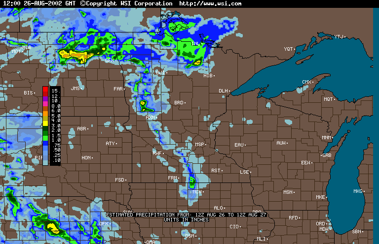
WSI radar-based
precipitation estimate - 24 hour totals ending 7:00 AM, August 27
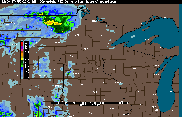
WSI radar-based precipitation estimate -
24 hour totals ending 7:00 AM, August 28
The State Climatology Office thanks
Soil and Water Conservation Districts in the affected areas for their
prompt and thorough response to our request for precipitation data.
Data were also provided by the National Weather
Service. We thank Minnesota's many volunteer precipitation monitors, whose
diligent efforts make detailed analysis of storm events possible.

 Return to the Climate Journal Return to the Climate Journal
mcwg@soils.umn.edu
URL:
http://climate.umn.edu/doc/journal/flash_floods/ff020827-28.htm
Last modified: August 28, 2002
|