Heavy Rains
Soak Portions of Wilkin County
August 28, 2002
Heavy rain produced by slow moving thunderstorms
deposited five to six inches of rain onto portions of Wilkin county during the evening hours of
Wednesday, August 28. The highest
reported 24-hour rainfall total was 5.50
inches in the city of Breckenridge. The heavy rain band was
geographically isolated, covering a narrow band from just west of
Wahpeton, ND to six miles east-northeast of Breckenridge. Rainfall
totals in this five mile wide stripe exceeded four inches. An
anectodotal report from Wahpeton claims seven inches of rain fell
during the event. Urban flooding was reported in the
Wahpeton/Breckenridge area. To demonstrate the highly variable spatial
extent of the event, rainfall totals from other portions of the city
of Breckenridge were less than three inches.
In the affected areas, a 24-hour rainfall total
of six inches is considered to be a one percent
probability occurrence.
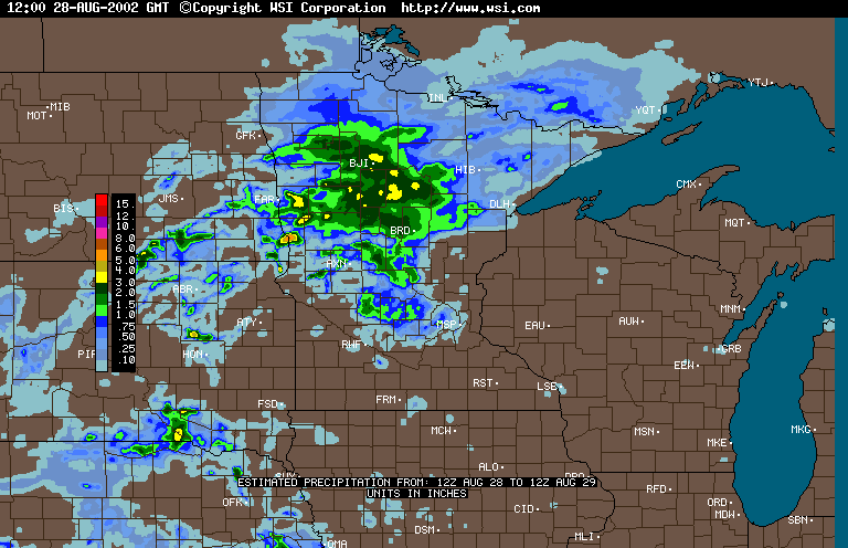
National Weather Service radar
imagery can be used to estimate precipitation totals in near real-time. A private vendor (WSI) purchases radar data from the National Weather Service and utilizes the data to prepare
the precipitation estimates offered in the hyperlink below. Precipitation estimates from radar returns are often fraught with errors.
Attenuation from heavy rain, enhanced reflection due to hail, and
distance from the radar site, can cause radar-based estimates to over or
under estimate true precipitation totals. For these reasons, this
technology may never replace the need for ground-based precipitation
measurements.
WSI radar-based
precipitation estimate - 24 hour totals ending 7:00 AM, August 29
The State Climatology Office thanks
Soil and Water Conservation Districts in the affected areas for their
prompt and thorough response to our request for precipitation data.
Data were also provided by the National Weather
Service. We thank Minnesota's many volunteer precipitation monitors, whose
diligent efforts make detailed analysis of storm events possible.

 Return to the Climate Journal Return to the Climate Journal
mcwg@soils.umn.edu
URL:
http://climate.umn.edu/doc/journal/flash_floods/ff020828.htm
Last modified: August 29, 2002
|