Heavy Rains Over South Central Minnesota
June 8-9, 2004
Summary
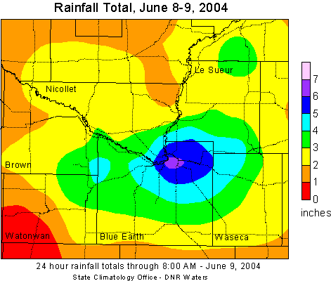
A series of thunderstorms formed along a stalled cold front over south central Minnesota and dumped very heavy rains as the storms drifted to the east. The highest total found was in Lime Township, 5 miles NE of Mankato with 7.05 inches. Another report of 7 inches was reported in North Mankato. The thunderstorms began late in the evening of June 8th with the heaviest rain falling in the wee hours of the morning on June 9th. This resulted in wet basements, overland flooding and mudslides on Highway 169 between Mankato and St. Peter. Highway 169 was closed for a time during the early morning hours of the 9th. The rain tapered off in the morning hours, but new thunderstorms redeveloped during the day. The map below reflects rainfall totals for the 24 hour period ending in the morning of June 9.
The State Climatology Office thanks the Soil and Water Conservation Districts,
the National Weather Service, and all of the diligent
volunteer precipitation observers who make analyses of these events possible.
The Chanhassen National Weather Service also has a web page of the June 8-9 Heavy Rain Event along with a map of estimated rainfall from the National Weather Service radar imagery.

 Return to
Minnesota Climatology Working Group Main Page Return to
Minnesota Climatology Working Group Main Page
URL: http://climate.umn.edu/doc/journal/flash_floods/ff040608-09.htm
Last modified: June 8-9, 2004
|