Heavy Rains Over Southeast Minnesota
June 8-9, 2004
Summary
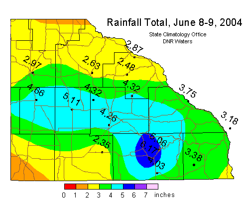
Heavy rains fell in two waves over southeast Minnesota on June 8 and 9, 2004. The remnants of the torrential rains that caused
flooding and mudslides in the Mankato area drifted east over southeast Minnesota late on June 8 and into the early morning hours
of June 9. Later in the morning of June 9, thunderstorms redeveloped over south central and southeast Minnesota and continued
throughout the afternoon and early evening. The Rochester airport recorded 4.06 inches of rain on June 9, setting a record for
the date. Another 0.20 inch had fallen on June 8, leading to a two-day total of 4.26 inches. The highest rainfall total for
the period in southeast Minnesota was 6.17 inches at Preston. By late in the evening of June 9, most of the heavy rain had
moved into Wisconsin. The rains fell upon soil already saturated from the heavy rains of
May 2004.
The deluge led to street flooding and wet basements in Rochester. One apartment building in Rochester had water
flowing through the lowest floor. Numerous accounts of water overtopping roads were reported throughout the region. A
mudslide was reported across Highway 250 just north of Lanesboro.

 Return to
Minnesota Climatology Working Group Main Page Return to
Minnesota Climatology Working Group Main Page
URL: http://climate.umn.edu/doc/journal/flash_floods/ff040610.htm
Last modified: June 10, 2004
|