Heavy Rains Over a Small Part of Southwest Minnesota.
August 23-24, 2004
Summary
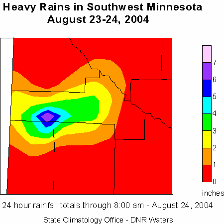
An area of thunderstorms developed during the afternoon of August 23rd over southwest Minnesota and drifted very slowly to the northeast before stalling over the junction of Yellow Medicine, Lyon and Lincoln Counties. The area covered by the very heavy rain was small but intense in a few areas. The highest total reported was 8.75 inches in the northeast corner of Lincoln County just south of Porter. Water ran over a few county roads in spots. The water appeared to recede rapidly and was eagerly soaked in by the ground. Another high amount was 7.14 inches just east of Porter in Yellow Medicine County. The storms diminished during the early morning hours of the 24th.
The State Climatology Office thanks the Soil and Water Conservation Districts,
the National Weather Service, and all of the diligent
volunteer precipitation observers who make analyses of these events possible.
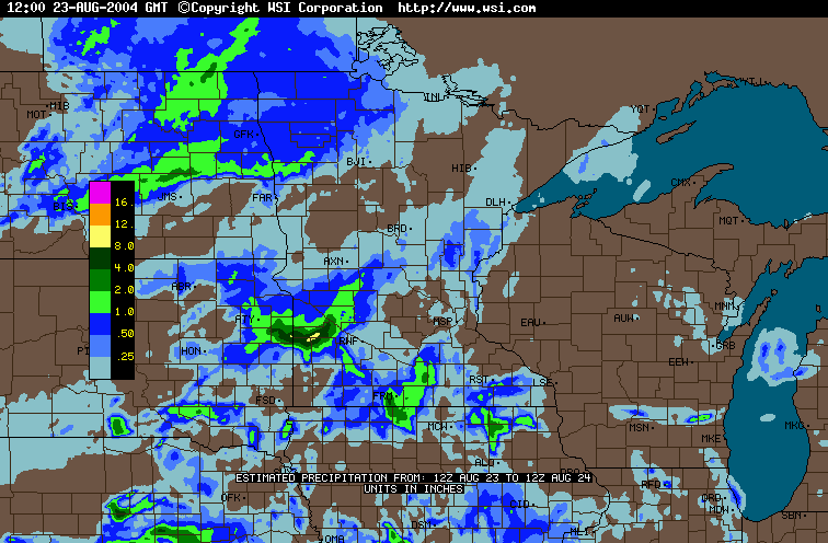
The image below provides a daily estimate of precipitation values for the period 7:00 AM, Monday - August 23 through 7:00 AM, Tuesday - August 24. The data are provided by the WSI Corporation's (http://www.intellicast.com) analysis of National Weather Service radar imagery.
Total Rainfall from Radar-based Estimates - August 23 and 24
(through 7:00 AM)

 Return to
Minnesota Climatology Working Group Main Page Return to
Minnesota Climatology Working Group Main Page
Error processing SSI file
URL: http://climate.umn.edu/doc/journal/flash_floods/ff040824.htm
Last modified: August 25, 2004
|