Torrential Rains Fall Upon West Central Minnesota
August 25-26, 2005
A sluggish cold front draped across western and central Minnesota spawned severe thunderstorms during the afternoon and evening hours of August 25 and the
early morning hours of August 26. The storms produced hail, high winds, and torrential rains over a multi-county area.
High rainfall rates over short time periods led to urban and rural flooding. This was especially true in locations where soils were
already damp from previous August rains. Urban flooding was reported Clay and Wilkin counties. Water was several feet deep in some Fargo streets
and Rothsay High School experienced flooding after the thunderstorms dropped over two inches of rain in less than hours. Nearly three inches of rain
was reported in Glenwood of Pope county between 10pm and midnight on the 25th, causing ankle-deep water in some city streets. Water one to three feet
deep was reported in parts of Alexandria.
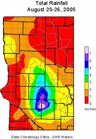
The locations with the greatest rainfall totals were located in Douglas, Pope, eastern Swift, Kandiyohi, and western Stearns counties. The
highest 24-hour rainfall total was 8.30 inches about three miles west of New London in Kandiohi County. 8.18 inches was reported one mile southwest of the city of Kerkhoven in southeast Swift County. Other totals included
6.72 inches southeast of Sundburg in Kandiyohi County, New London with 5.52 inches, 5.45 inches at Carlos in Douglas County and five inches at Glenwood.
The State Climatology Office thanks the Soil and Water Conservation Districts, the National Weather Service, and
all of the diligent volunteer precipitation observers who make analyses of these events possible.

 Return to Minnesota Climatology Working Group Main Page
URL: http://climate.umn.edu/doc/journal/flash_floods/ff050826.htm
Last modified: September 1, 2005
|