Heavy Rains Fall on Southeastern Minnesota - June 23 thru June 28, 1998
Very heavy rains fell across a large portion of southeastern Minnesota during the week ending June 28. Multi-day totals exceeding eight inches were reported in Scott, Rice and Goodhue counties. A location near Zumbrota in Goodhue county reported 10.03 inches of precipitation over the period.
The rains began during the evening hours of June 23 and continued into the morning of June 24. One half inch to three inches of rain fell across much of southeastern Minnesota during this event, dampening soils in advance of the heavier rains to come.
Late in the evening of the 24th, and early on the 25th, thunderstorms once again targeted southeastern Minnesota. Rainfall totals were in the one to two inch category, further saturating the ground. Portions of Wabasha county received over three inches of rain during this event.
The heaviest of the rains fell during the late afternoon and evening of Friday, June 26th. Over the course of roughly six hours, the torrential rains left a swath of three to six inch totals across Scott, Rice, and Goodhue counties. The deluge created flash flooding which led to serious soil erosion, property damage, and the loss of two lives.
Yet another complex of thunderstorms rumbled through southern Minnesota during the evening of June 27th. The rains of the 27th totaled roughly one inch in the previously affected areas, but deposited two to four inches across the southern-tier counties; Faribault, Freeborn, Mower, and Fillmore.
Radar-based precipitation estimates, provided by the WSI Corporation, were combined to form a different look at the multi-day totals. The radar-based data show the extraordinary rainfall totals extending from southeastern Minnesota well into central Wisconsin.
![]()
mcwg@soils.umn.edu
URL:
http://climate.umn.edu/doc/journal/ff980628.htm
Last modified: June 30, 1998
 Return to the Climate Journal
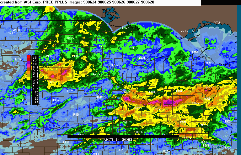