Snowstorm of January 25-27, 2004
A large-scale snowstorm struck Minnesota over a three-day period from Sunday January 25th and continued through the morning hours of Tuesday January 27th. All four corners of the state saw snow from a rather complex weather system. The most snow was in northeast Minnesota where Lake Superior enhanced snow bands added to the totals. By the time the snow tapered off to flurries a site 7 miles from Two Harbors picked up 30.5 inches of snow. This is still over a foot short of the state-wide all time snowstorm total that was set at Wolf Ridge back on January 6-8, 1994 when 46.5 inches of snow fell. The 27.1 inches that fell at Duluth did make this storm the 3rd largest snowstorm on record for Duluth.
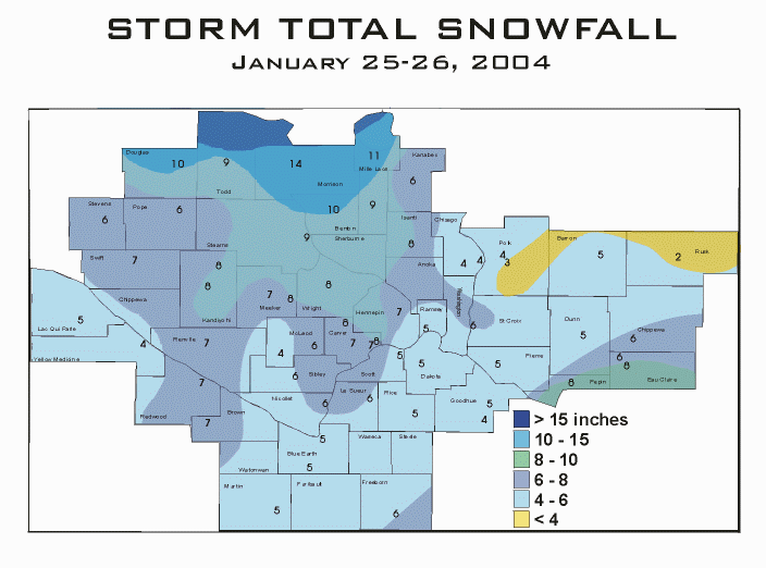
Map of January 25-26, 2004 snow event from the Chanhassen National Weather Service.
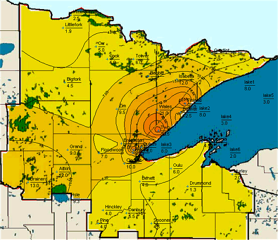
Map of January 25-27, 2004 snow event from the Duluth National Weather Service.
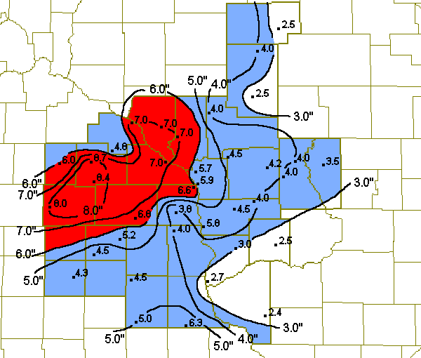
Map of January 26-27, 2004 snow event from the La Crosse National Weather Service.
Listed below are some snowfall totals from this event courtesy the National Weather Service.
NATIONAL WEATHER SERVICE DULUTH MN...UPDATE FOR ADDITIONS
1050 AM CST TUE JAN 27 2004 THESE ARE STORM SNOWFALL TOTALS FROM COOPERATIVE AND SNOWFALL OBSERVERS.

NORTHEAST MINNESOTA                  SNOWFALL SNOW DEPTH
KOOCHICHING COUNTY
====================
INTERNATIONAL_FALLS...........         2.5    15.0
LITTLEFORK_10SW...............         1.9    14.0

ITASCA COUNTY
====================
SQUAW_LAKE....................         5.0    15.0
GRAND RAPIDS 5SE..............         9.0       M
BIGFORK.......................         4.5       M
AITKIN COUNTY
====================
AITKIN........................        12.0       M
ISLE_12N......................         9.3       M

ST. LOUIS COUNTY
====================
ADOLPH_1N.....................        25.0       M
AURORA........................         6.0       M
BABBITT.......................         8.0       M
BROOKSTON.....................         7.0    18.0
COOK..........................         4.0    19.0
DULUTH_WFO....................        27.1    31.0
DULUTH CONDGON.................       14.0       M
DULUTH WEST END...............        18.0       M
FLOODWOOD.....................         7.0       M
HIBBING.......................         6.5     9.0
ORR...........................         5.0    21.0
TOWER_3S......................         6.0    20.0
ZIM...........................         9.5       M
CRANE LAKE....................         4.0       M
CARLTON COUNTY
===================
CLOQUET.......................        10.0       M

LAKE COUNTY
====================
BEAVER_BAY....................        12.5       M
FINLAND.......................        26.0       M
ISABELLA_1W...................        12.0    29.0
SILVER_BAY....................        13.3       M
TWO_HARBORS_7NW...............        30.5    35.0
WALES_2E......................        21.0       M
PINE COUNTY
====================
HINCKLEY......................         4.0       M
PINE_CITY_2NE.................         4.0    10.5
COOK COUNTY
====================
TOFTE 23N.....................         4.0    27.0
GUNFLINT TR...................         3.8    24.0

NORTHWEST WISCONSIN                  SNOWFALL SNOW DEPTH

DOUGLAS COUNTY
====================
BENNETT_25S_SUPERIOR..........         4.0       M
SUPERIOR......................        10.0       M
BAYFIELD COUNTY
====================
CORNUCOPIA_4S.................         4.5       M
DRUMMOND......................         1.3    13.0
OULU..........................         6.0    16.0

BURNETT COUNTY
====================
DANBURY.......................         5.5       M
WASHBURN COUNTY
====================
SPOONER.......................         4.5     9.0


PUBLIC INFORMATION STATEMENT
NATIONAL WEATHER SERVICE TWIN CITIES/CHANHASSEN MN
825 PM CST MON JAN 26 2004
HERE ARE SOME OFFICIAL AND UNOFFICIAL SNOWFALL REPORTS AS OF
600 PM THIS EVENING...

CITIES              AMOUNT IN INCHES
CHANHASSEN                7.6
BUFFALO                   7-8
ALBERT LEA              4.0-5.0
FAIRMONT                  5.0
MILACA                  8.0-10.0
MORRIS                    6.0
LONG PRAIRIE             8.0-10
LITTLE FALLS              14.0
GRANITE FALLS             4.0
GLENWOOD                  6.0
GILMAN                   10.0
ST CLOUD                  8.5
AMBOY                     5.0
MANKATO                   4-5
ST PETER                  5-6
ZUMBROTA                  3-4
ST PAUL                   4-5
ONAMIA                   10-11
NEW HOPE                  6-7
NEW LONDON                7-8
OLIVIA                    6-8
WILLMAR                   7-8
LITCHFIELD                6-7
REDWOOD FALLS             5-6
DAWSON                    4-5
BENSON                    6-7
BROWNTON                  4.0
CHASKA                    6-7
CARLOS(ALEXANDRIA)       10.0
DASSEL                    7-8
SPRINGFIELD               6-7
ST PETER                  4-5
MONTGOMERY                6.0
FARMINGTON                5.0
ALBERT LEA                5.5
GOODHUE                   5.0
GLENCOE                   6.0
GAYLORD                   6.0
MORA                      6.0
REDWOOD FALLS             7.0
FARIBAULT                 4-5
WATERTOWN                 6.8
WACONIA                   7.0
WISCONSIN...
POLK COUNTY               3-4
DUNN COUNTY               3-4
EAU CLAIRE                3.5
ST. CROIX                 4-5

....AS OF 8 PM THIS EVENING...

WEAU TV
EAU CLAIRE                5.8
WQOW TV
EAU CLAIRE                4.5

 Return to
Minnesota Climatology Working Group Main Page Return to
Minnesota Climatology Working Group Main Page
URL: http://climate.umn.edu/doc/journal/snow040125_27.htm
Last modified: February 4, 2004
|