|
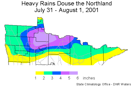
Torrential rains fell upon far northern Minnesota
on July 31 and August 1. The first of a sequence of thunderstorms
entered northwestern Minnesota during the early morning hours of the
31st. The last of the storms finally exited northeastern Minnesota
approximately 24 hours later. In their wake, the storms left a swath of
two to six inches of rain. The heavy rain led to rising streams, urban
flooding and road wash-outs. The heaviest rain fell in portions of Lake
of the Woods, Beltrami, and Koochiching counties. Rainfall amounts
topping five inches were common in these counties. Scattered within this
three county area were isolated unofficial reports of six to seven
inches. The highest official total reported was 5.97 inches at Baudette
in Lake of the Woods county. An automated weather station near Baudette
indicated that nearly three inches of rain fell in a two hour period
between 6:00 pm and 8:00 pm on the 31st.

 Return to the Climate Journal Return to the Climate Journal
mcwg@soils.umn.edu
URL:
http://climate.umn.edu/doc/journal/flash_floods/ff010801.htm
Last modified: August 1, 2001
|