Heavy Rains Again Fall Over Central Minnesota September 5-6, 2002
Two waves of thunderstorms brought very heavy rains and some
scattered reports of severe weather over central Minnesota on September 5th and 6th. The first wave of
thunderstorms moved to the northeast across the Twin Cities during the evening
rush hour of Thursday, September 5th. These thunderstorms brought vicious
lightning and strong winds over the eastern Twin Cities metropolitan area. Some wind damage
was reported in White Bear Lake.
A second wave of thunderstorms began near St. Cloud around 9:00 PM on Thursday evening and slowly moved first to the east,
then drifted southward as the night went on. The storms dropped golf ball-sized near Dassel in Meeker County.
The line of storms then expanded to the east and sagged to the south. Booming thunder awakened many in the Twin
Cities during the early morning hours of Friday September 6th. There was a vivid show of lightning.
On the western edge of this line of storms, more thunderstorms developed through the night, passing over
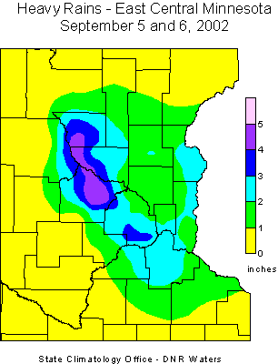
the same areas hour after hour. The result was a swath of rainfall totals of 3 to 5 inches from
near Foley in Benton County to near Rockford in eastern Wright County. The highest total reported to
the State Climatology Office was 6.00 inches at the Wright County Soil and Water Conservation District Office in
Buffalo. The St. Cloud Airport saw 4.39 inches, while the St. Cloud State University campus reported 4.48 inches.
Most places in the Twin Cities recorded 2.00 to 3.00 inches of rain. Normal rainfall for the entire month of September
in the Twin Cities is 2.69 inches.
Areas from just west of Foley in Benton county, to Buffalo in Wright county received the most damage. A bridge was reported
underwater on County Road 25 at Popple Creek of Benton county. Another bridge which was under construction
was washed out on County Road 4 west of County Road 3 in Benton county. St. Cloud had numerous cars stalled
in low areas and underpasses within the city. Flash flooding was also reported in Buffalo with flooded businesses on
Main Street. County Road 12 in Buffalo was barricaded due to flooding. There were reports that the northern Twin Cities
also had some intersections underwater during the early hours of the 6th. By midday on the 6th, the
thunderstorms had diminished or moved father southeast.
WSI radar-based
precipitation estimate - September 6
A labeled-line, black-and-white
Windows Metafile (wmf) version of the color map can be obtained by
right-clicking on this link
and choosing "Save Target As" or "Save Link As".
This version of the map will be useful for insertion into
documentation that requires inexpensive photo-reproduction.

 Return to the Climate Journal Return to the Climate Journal
mcwg@soils.umn.edu
URL:
http://climate.umn.edu/doc/journal/flash_floods/ff020905-06.htm
Last modified: September 6, 2002
|