Heavy Rains and Severe Weather
Pound Central and Southern Minnesota
June 21-25, 2003
Summary
A multi-day onslaught of thunderstorm complexes brought extraordinarily heavy rainfall
and severe weather to central and southern Minnesota for the period June 21 through June 25.
The heavy rains led to numerous reports of damaging urban and rural flooding. In addition to the
torrential downpours, the thunderstorms spawned tornadoes, damaging winds, and hail. (see:
compilation of storm reports).
A tornado devastated the city
of Buffalo Lake in Renville county during the evening of June 24.
Rainfall totals for the five-day period topped six inches along a 30 mile wide band stretching from
Traverse county in west central Minnesota to Pine county in east central Minnesota. Total
rainfall exceeded eight inches in some areas embedded within this swath. Rainfall
amounts also surpassed six inches in some areas of Kandiyohi, Renville, Meeker,
Wright, Sherburne, Hennepin and Chisago counties during the week.
Much of the rain in central Minnesota fell within a 48 hour period between June 22 and June
24. In Minnesota, the historical probability of receiving eight inches of rain within 48
hours for a given location is less than one percent per year. The heaviest
rain in southern and east central Minnesota fell within a 12 hour period on June 24-25.
The historical probability of receiving six inches of rain within 12 hours for a given
location is less than one percent per year. (see: Rainfall Frequency Atlas of the Midwest.)
Radar-based precipitation estimates are occasionally limited by problems related
to artificial returns due to ground clutter and hail, the interception of the radar beam by
intervening precipitation, and the curvature of the earth. However,
for the storms of June 21-25 the radar-based precipitation estimates
compared quite well with ground-based data gathered by volunteers
working with Soil and Water Conservation Districts, the Metropolitan Mosquito Control District,
and the National Weather Service. To provide the greatest amount of spatial detail
possible, radar-based images are offered in this narrative.
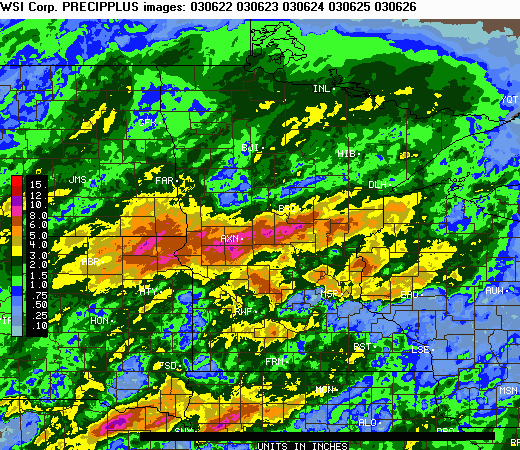
The image below provides a multi-day estimate of precipitation values for
the period 7:00 AM, Saturday - June 21 through 7:00 AM, Thursday - June
26. The data are provided by the WSI Corporation's (http://www.intellicast.com)
analysis of National Weather Service radar imagery. To create this
image, five distinct 24-hour precipitation total images were summed
using graphical techniques developed by the State Climatology
Office.
Total Rainfall from Radar-based Estimates - June 21 through June 26
(through 7:00 AM)
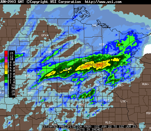
Heavy Rain - June 22 and 23
For many areas of central Minnesota, the heaviest rain fell during the evening hours of Sunday, June 22 and into
the early morning of Monday, June 23. 24 hour totals in excess of six inches were reported
in northern Morrison, southern Aitkin, and northern Kanabec counties. The largest 24 hour total
reported was 7.00 inches in Pulaski Township of Morrison county.
24 Hour Radar-based Rainfall Estimates - June 22 through June 23 (7:00
AM through 7:00 AM)
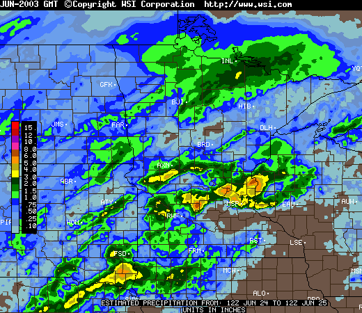
Heavy Rain - June 24 and 25
In southern and east central Minnesota, the heaviest rainfall fell during the evening hours of
Tuesday, June 24 and into the early morning of Wednesday, June 25. 24 hour totals in excess of
six inches were reported in western Renville, eastern Wright, southern Sherburne, central Hennepin,
and central Chisago counties.
24 Hour Radar-based Rainfall Estimates - June 24 through June 25 (7:00
AM through 7:00 AM)
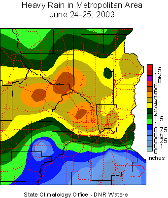 The map at right was compiled using rainfall measurements made by volunteer observers located throughout
east central Minnesota. The largest 24 hour total reported was 8.19 inches in Elk River of Sherburne county.
Some of the larger rainfall totals in the metropolitan area for June 24-25 include:
The map at right was compiled using rainfall measurements made by volunteer observers located throughout
east central Minnesota. The largest 24 hour total reported was 8.19 inches in Elk River of Sherburne county.
Some of the larger rainfall totals in the metropolitan area for June 24-25 include:
|
Sherburne county
|
Hennepin county
|
|
Elk River - 8.19"
|
Plymouth - 6.68"
|
|
|
Brooklyn Park - 6.50"
|
|
Wright county
|
Brooklyn Center - 6.00"
|
|
Monticello - 7.50"
|
downtown Mpls. - 5.90"
|
|
Buffalo - 6.25"
|
New Hope - 5.83"
|
|
Rockford - 4.50"
|
Robbinsdale - 5.75"
|
|
Cokato - 4.19"
|
south Mpls. - 5.55"
|
|
|
St. Louis Park - 5.28"
|
|
Anoka county
|
Maple Grove - 5.14"
|
|
Fridley - 5.32"
|
Corcoran - 5.00"
|
|
|
Hassan - 4.80"
|
|
Ramsey county
|
Champlin - 4.71"
|
|
St. Paul midway - 4.98"
|
Golden Valley - 4.70"
|
|
St. Paul (Como) - 4.65"
|
Dayton - 4.60"
|
|
Maplewood - 4.59"
|
|
|
Little Canada - 4.55"
|
Chisago county
|
|
Falcon Heights - 4.52"
|
North Branch - 6.00"
|
|
St. Paul (Holman) - 4.31"
|
Taylors Falls - 4.00"
|
|
Vadnais Heights - 4.17"
|
|
|
White Bear Lake - 4.10"
|
Washington county
|
|
Shoreview - 4.07"
|
Scandia - 4.71"
|
|
|
Forest Lake - 4.01"
|
The State Climatology Office thanks the Soil and Water Conservation Districts,
the Metropolitan Mosquito Control District, the National Weather Service, and all of the diligent
volunteer precipitation observers who make analyses of these events possible.

 Return to
Minnesota Climatology Working Group Main Page Return to
Minnesota Climatology Working Group Main Page
URL: http://climate.umn.edu/doc/journal/flash_floods/ff030622-25.htm
Last modified: June 26, 2003
|