Heavy Rains Over Southwest Minnesota
June 15-16, 2004
Summary
Heavy rains fell over southwest Minnesota beginning shortly before midnight on June 15th
and continued through the morning hours of June 16. The heaviest rain fell in two areas.
One area plagued Sioux Falls, SD with a total of 3.57 inches at the airport and 7.79 inches
5 miles southwest of town. City officials called it the worst flooding in Sioux Falls in 10 years.
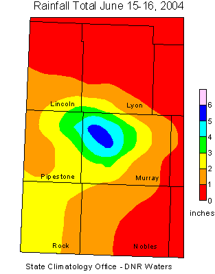
Another area of heavy rains fell over southwest Minnesota, especially western Murray County.
The highest reported total in Minnesota was 6.35 inches in Cameron Township just north of
Lake Wilson. Lake Wilson received 5.56 inches of rain. The heavy rains caused severe erosion
in Murray county with numerous township roads underwater. Some roads were washed out.
Pipestone County also saw heavy rains with flooding of pasture land and reports of
wet basements. The highest rainfall total reported in Pipestone County was 3.75 inches
near Holland. The Pipestone Creek in Pipestone rose 4 feet in twelve hours and was
briefly above flood stage. The rains fell upon soil already saturated from the heavy rains of
May 2004.
The State Climatology Office thanks the Soil and Water Conservation Districts,
the National Weather Service, and all of the diligent
volunteer precipitation observers who make analyses of these events possible.
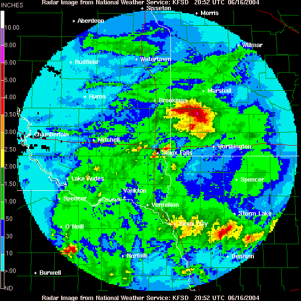
Below is radar imagery from the Sioux Falls National Weather Service depicting the storm total.
Listed below are some storm reports and rainfall totals courtesy the National Weather Service.
PRELIMINARY LOCAL STORM REPORT
NATIONAL WEATHER SERVICE SIOUX FALLS SD
109 PM CDT THU JUN 17 2004
..TIME...   ...EVENT...     ...CITY LOCATION...      ...LAT.LON...
..DATE...   ....MAG....     ..COUNTY LOCATION...ST.. ...SOURCE....
           ..REMARKS..

1130 PM  FLASH FLOOD    CURRENT LAKE 44.14N 95.94W 06/15/2004  MURRAY  MN   EMERGENCY MNGR
3 TO 6 INCHES OF RAIN FELL IN LESS THAN 3 HOURS. NUMEROUS
TOWNSHIP ROADS UNDER WATER WITH SOME ROADS WASHED OUT.
AGRICULTURAL FIELDS FLOODED. DURATION OF EVENT COVERS SEVERAL HOURS.

PUBLIC INFORMATION STATEMENT...CORRECTED
NATIONAL WEATHER SERVICE SIOUX FALLS SD
216 PM CDT WED JUN 16 2004

CORRECTED MND HEADER

...SOME RAINFALL REPORTS FROM 7 PM YESTERDAY UNTIL 1 PM CDT...

ROCK VALLEY IA.......................0.28 INCHES
MADISON..............................0.34 INCHES
LAKEFIELD MN.........................0.35 INCHES
YANKTON..............................0.41 INCHES
WALL LAKE............................0.51 INCHES
ASTORIA..............................0.59 INCHES
BROOKINGS............................0.71 INCHES
WINDOWM MN...........................0.78 INCHES
AKRON IA.............................0.91 INCHES
STORM LAKE IA........................0.92 INCHES
MITCHELL.............................0.52 INCHES
CROOKS...............................1.10 INCHES
WAGNER...............................1.14 INCHES
SIOUX CITY AIRPORT...................1.20 INCHES
PIPESTONE MN.........................1.21 INCHES
TYNDALL..............................1.35 INCHES
LAKE BENTON MN.......................1.53 INCHES
SIOUX FALLS.......6 MI SOUTH.........3.10 INCHES
SIOUX FALLS.......6 MI SOUTHEAST.....3.47 INCHES
SIOUX FALLS AIRPORT..................3.57 INCHES
SIOUX FALLS.......6 MI SOUTHEAST.....4.10 INCHES
LAKE WILSON MN.......................5.56 INCHES
SIOUX FALLS.......5 MI SOUTHWEST.....6.02 INCHES
SIOUX FALLS.......5 MI SOUTHWEST.....7.79 INCHES

 Return to
Minnesota Climatology Working Group Main Page Return to
Minnesota Climatology Working Group Main Page
URL: http://climate.umn.edu/doc/journal/flash_floods/ff040616.htm
Last modified: June 18, 2004
|