Heavy Rains and Severe Weather Over Southeast Minnesota
June 7-8, 2005
Several waves of strong thunderstorms moved across the state on June 7th and 8th, 2005.
The first batch of storms moved to the east across southern and central Minnesota during
the morning hours of June 7th. Hail the size of quarters fell across Vadnais Heights in
the Twin Cities. The clouds cleared by late morning and very warm sticky air settled over
the state by the afternoon. Fairmont hit 93 degrees with many places breaking 90 across
southern Minnesota. The Twin Cities saw its first 90 degree temperature of the year
with a high of 91.
In the late afternoon, severe thunderstorms developed along a stationary front in
west central Wisconsin and southern Minnesota. The thunderstorms moved slowly north
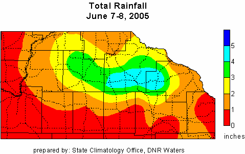
and dumped heavy rains over Wabasha, Goodhue, Rice and Le Sueur counties.
A large area of thunderstorms at the same time covered a massive area over eastern South Dakota
associated with an area of low pressure.
This area of storms formed a bow echo and marched eastward across Minnesota in the wee hours
of the morning on June 8th. The front edge of the storms moved across the Twin Cities from
3am to 5am. Damaging winds accompanied these storms and 94,000 power outages were reported
in the Twin Cities, the highest power outage total in two years.
This line also moved over the same area saturated by the thunderstorms over southeast Minnesota.
Hardest hit were Goodhue and Wabasha Counties. 6.43 inches of rain fell in 24 hours at Zumbro Falls, 5.50
inches fell at Wanamingo. Water from the Zumbro River flooded over Highway 58 and closed the road.
Sandbagging was underway on the morning of June 8th in low lying spots in Zumbrota.
One woman was rescued and one man died after thier separate vehicles were swept off Highway 1
and into an unnamed creek that flows into the Zumbro River in Goodhue County.
By late morning of June 8th, most of the rain had exited Minnesota into Wisconsin.
A six inch rainfall total for a given location in this region over a 24 hour period is said to be a "100-year storm". In this case portions of Goodhue County saw 6 inches of rain in 24 hours. Places like Wanamingo and Zumbro Falls saw 5 inches in a 12 hour period which is also a "100-year storm"

The State Climatology Office thanks the Soil and Water Conservation Districts, the National Weather Service, and
all of the diligent volunteer precipitation observers who make analyses of these events possible.

 Return to Minnesota Climatology Working Group Main Page
URL: http://climate.umn.edu/doc/journal/flash_floods/ff050607_08.htm
Last modified: July 6z, 2005
|