Heavy Rains Fall on Minnesota - July 1, 1997
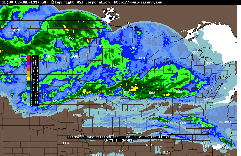
For the third time in the past week, heavy rains fell across portions of northwestern and/or central Minnesota.
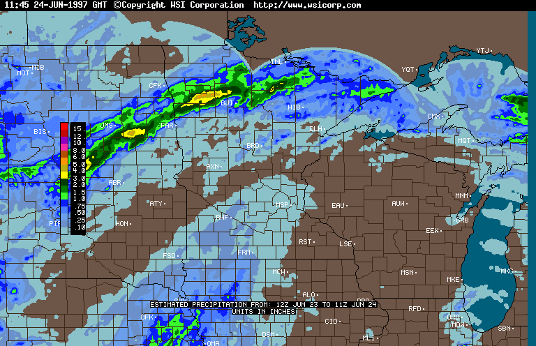
Rainfall amounts of one to four inches were reported in the northwestern Minnesota counties of Red Lake, Pennington, Marshall, and Kittson. Portions of Red Lake County received three to four inches of rain only one week earlier.
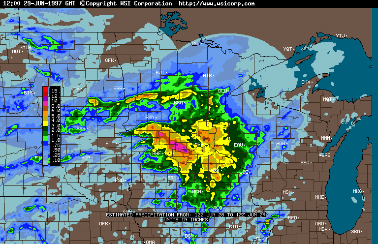
Rainfall amounts of one to four inches also stretched across central Minnesota from Lac Qui Parle and Yellow Medicine counties, through the Twin Cities metropolitan area, and into Wisconsin. The heavy rains fell on central Minnesota counties that were drenched by four to five inch totals this past weekend. Portions of Kandiyohi, Mcleod, and Meeker counties have reported over eight inches of rain since Saturday, June 28.
Although rainfall totals from the July 1 event did not match last weekend's deluge, rainfall intensities were higher. The St. Paul campus of the University of Minnesota reported three inches of rain in less than one hour. The very intense rainfall rate exceeded the so-called "100-year event". A "100-year storm" means that for each year at a given location, the location has a one in one hundred chance of receiving that amount of precipitation or greater (for the designated time interval, in this case one hour). By comparison, the greatest 60 minute precipitation total during the "Superstorm" of July 23-24, 1987 at the Twin Cities International Airport was 2.78.
Radar-based precipitation estimates are available for the 24 hour periods ending 7 AM: June 24, 1997, June 29, 1997, and July 2, 1997.
Station-by-stations rainfall totals for July 1, 1997 follow:
ADAMS           1.33 ALBERT LEA      0.01 ALEXANDRIA      0.96
ALVARADO        2.00 ARGYLE          1.82 BELGRADE        1.61
BENSON          1.43 BRAINERD        0.51 BRECKENRIDGE    0.65
BRICELYN        0.06 BROOKLYN PARK   2.63 BURNSVILLE      1.49
CHANHASSEN      1.19 CHASKA          1.32 DELANO          1.85
DULUTH          0.62 PINE RIVER DAM  0.90 FLOODWOOD       0.50
FOREST LAKE     2.27 FOSSTON         0.21 FRIDLEY         2.12
GOLDEN VALLEY   3.72 GREENBUSH       1.78 GULL LAKE       0.62
HASTINGS        1.88 HALSTAD         1.45 HENDERSON       0.10
HIBBING         0.60 HINCKLEY        0.30 HUTCHINSON      1.70
INTL FALLS      1.05 ISLE            0.33 LAMBERTON       0.00
LANCASTER       4.00 LITCHFIELD      3.20 LITTLEFORK      0.57
LONG PRAIRIE    0.87 MANKATO         0.41 MILAN           1.86
MINNEWAUKEN     2.50 MPLS/STP AIRPOR 2.85 SOUTH MPLS      3.60
MONTEVIDEO      1.68 MOUND           2.14 OLIVIA          0.96
ONAMIA          0.66 PELICAN RAPIDS  0.37 PINE RIVER DAM  0.90
POKEGAMA LAKE D 0.43 PRESTON         0.16 RED LAKE FALLS  4.72
RED WING        1.72 REDWOOD FALLS   0.13 REMER           0.45
ROCHESTER          T SAVAGE          1.55 ST CLOUD        1.26
ST CROIX FALLS  2.23 U OF M ST PAUL  3.67 ST PETER        0.05
RUSHFORD        0.10 SANDY LAKE      0.73 SPRING LAKE PK  3.90
STEWART         0.18 STILLWATER      3.42 STILLWATER #2   3.22
WABASHA         0.04 WADENA          0.93 WARREN          3.66
WARROAD         1.55 WASECA             T WASKISH         0.66
WATSON          2.35 WINSTED         2.18 WOODBURY        2.76
![]()
mcwg@soils.umn.edu
URL:
http://climate.umn.edu/doc/journal/ff970702.htm
Last modified: July 2, 1997
