Heavy Rains and Snow in Northwest Minnesota:
May 11-12, 2004
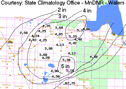
A large area of low pressure brought heavy rains over northwest Minnesota on May 11th and through the early morning hours of May 12th. Many places north and west of a line from Grand Forks to Bemidji and International Falls saw 2 to 4 inches of rain. The most rainfall reported as of 11am Wednesday May 12 was 5.37 inches in Lake township to the west of Warroad. Wannaska wasn't far behind with 5.30 inches. 4.48 inches fell at Warroad, Argyle saw 4.26 inches and Roosevelt in Lake of the Woods County saw 4.20 inches. Areal flood warnings continued through the day on the 12th for Roseau and Marshall Counties. Ditches were reported to be full and starting to overflow. Some township roads were reported to be covered with water in Rollis Township in eastern Marshall County.
Along with the rain came some wintertime precipitation as well. Roseau picked up 4.26 inches of rain and also a half inch of snow. 2.5 inches of snow was reported 4 miles west of Warroad along with thundersnow. Pembina just across the border of Minnesota near the Canadian border saw 4 inches of snow. Farther to the north, portions of southern Manitoba in Canada received up to 10 inches of snow along with roads closed near Winnipeg and numerous school closings. Heavy snow also fell during the day on May 12th in central North Dakota.
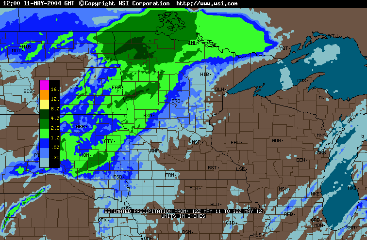
The image below provides a daily estimate of precipitation values for the period 7:00 AM, Tuesday - May 11 through 7:00 AM, Wednesday - May 12. The data are provided by the WSI Corporation's (http://www.intellicast.com) analysis of National Weather Service radar imagery.
Total Rainfall from Radar-based Estimates - May 11 and 12
(through 7:00 AM)
Map below created by Grand Forks National Weather Service using HIDEN rain gauge network.
Listed below are some precipiation totals courtesy the National Weather Service.
COOPERATIVE WEATHER OBSERVATIONS
NATIONAL WEATHER SERVICE EASTERN NORTH DAKOTA/GRAND FORKS
1104 AM CDT WED MAY 12 2004

HIGH TEMPERATURES PAST 24 HOURS (7AM - 7AM)
LOW TEMPERATURES PAST 24 HOURS (7AM - 7AM)
PRECIPITATION TOTAL PAST 24 HOURS (7AM - 7AM)

                         TEMPERATURE      RAINFALL
                         MAX     MIN      (24 HRS)
NORTH DAKOTA SITES

  GRAND FORKS NWS         44      35        1.69
  EDMORE                  33      30        0.50
  LANGDON                 33      29        1.47
  CASSELTON               60      37        1.40
  COLGATE                 42      34        0.75
  LEEDS                   39      30           M
  LIDGERWOOD              81      39        1.36
  PEMBINA                 35      32        1.76
  CAVALIER                33      31        1.16
  HANSBORO                34      29           T
  MCLEOD                  65      36        0.00
  MAYVILLE                39      35        1.11
  ADAMS                                     1.83
  CANDO                                     0.69
  CAYUGA                                    0.82
  SOUTH GRAND FORKS                         1.36
  GWINNER                                   1.65
  HAVANA                                    0.96
  LARIMORE                                  2.17
  MANTADOR                                  1.25

MINNESOTA SITES

  ADA                     50      37        0.05
  BLACKDUCK               51      35        3.20
  BRECKENRIDGE            81      40        1.30
  CROOKSTON               40      38        2.47
  DALTON 3S               82      41        1.53
  KARLSTAD                37      34        3.90
  NORRIS CAMP              M       M        4.20
  NEW YORK MILLS          78      44        1.39
  OTTERTAIL               80      40        1.50
  RED LAKE FALLS          38      35        3.15
  ROSEAU                   M       M        4.26
  SABIN                   69      39        1.96
  TAMERAC REFUGE          74      40        2.50
  WADENA                  79      47        1.59
  WARROAD                  M       M        4.48
  CAMPBELL                                  1.35
  DILWORTH  7NNE                            1.90
  GREENBUSH                                 3.51
  HALSTAD                                   3.30
  HAYES LAKE ST PK                          4.12
  ITASCA                                    1.65
  LANCASTER                                 1.65
  LONG LOST LAKE                            1.54
  NEW YORK MILLS 3NW                        1.44
  PELICAN RAPIDS 2N                         1.47
  ROTHSAY                                   1.34
  TWIN VALLEY                               2.15
  VIKING                                    2.73
  WANNASKA                                  5.30

THE FOLLOWING ARE AUTOMATED RAIN GAGES

 MINNESOTA                         NORTH DAKOTA

  ADA                     2.58       BAKER                  0.65
  BELTRAMI                1.95       BALDHILL DAM           0.34
  CAMPBELL                1.16       CANDO                  1.04
  FOXHOME                 0.24       CAVALIER               0.78
  HIGHLANDING             2.98       COOPERSTOWN            0.36
  HALLOCK                 1.31       FORREST RIVER          1.72
  HUMBOLT                    M       GALESBERG              1.04
  LAKE BRONSON            0.02       HILLSBORO                 M
  MALUNG                  0.08       HOMME DAM              1.04
  ORWELL DAM              1.21       LANGDON                   M
  OSLO                    3.38       MAYVILLE                  M
  PERLEY                  2.56       MCHENRY                0.42
  ROSEAU                  4.35       OAKES                  1.21
  RED LAKE DAM            2.28       PILLSBURY              1.24
  SHELLY                  2.26       WAHPETON                  M
  STEPHEN                    M       WALHALLA 6 SW          0.28
  LAKE TRAVERSE           0.13       WALHALLA                  M
  RADIUM                  1.96       WARWICK                0.06
  THF RVR FALLS DAM       3.62
  THIEF RIVER FALLS       3.24

 Return to Minnesota Climatology Working Group Main page
URL: http://climate.umn.edu/doc/journal/flood040512.htm
Last modified: May 12, 2004
|