Heavy Rains and Severe Weather: April 15-17, 2003
Widespread heavy rains brought welcome relief to the dry soils of Minnesota. The rain was from a slow moving deep low pressure area over Missouri. The heaviest rain fell in a band from north of Eau Claire to Breckenridge. One of the highest multi-day totals was at Pipestone with 4.24 inches. Many places in central and southern Minnesota received between one and two inches of rain. There also was some severe weather on April 15th with large hail reported near Tower. Some of the rain turned into sleet and snow over central and northern Minnesota on April 16th. 1.5 inches of sleet was measured at St. Cloud State University. One of the highest snowfall measurements was 3.7 inches at Littlefork.

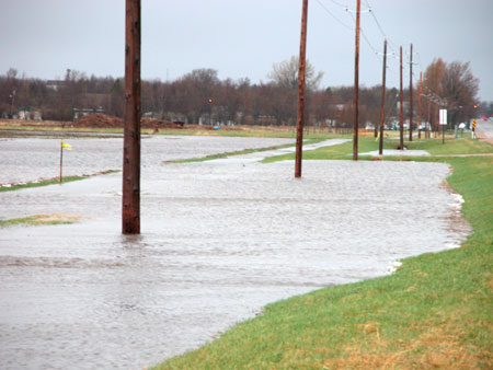
Photograph of overflowing ditch in Pipestone on April 16 from the Pipestone County Star.
Listed below are some multi-day rainfall totals from this event.
Pipestone            4.24
St. Cloud State      3.55
Zumbrota             2.30
Young America        1.68
Wabasha              1.88
Zumbrota             1.95
Minneapolis/St. Paul 1.90
Rochester            1.00
International Falls   .25
Duluth                .40
Brainerd             2.24
Alexandria           1.16
Browns Valley        1.90
Moorhead             1.66
Onamia               2.13
Ottertail            2.14
Mora                 1.91
Campbell             1.90
Sioux Falls           .72
Some large hail also fell in far nothern Minnesota. Golf-ball sized hail was reported just after midnight near Tower.

Large hail found near Lake Vermillion. Photograph by Jodi Summit of the Timberjay newspaper.

 Return to Minnesota Climatology Working Group Main page
URL: http://climate.umn.edu/doc/journal/heavyrain030417.htm
Last modified: April 30, 2003
|