Snowstorm
November 21-23, 2003
For the first time this winter season, a classic winter storm originated in the lower Great Plains. The storm
then moved through Missouri, across Iowa and into southern Wisconsin. This storm track put Minnesota in the favorable heavy snow band. Before the main storm even arrived there was a weaker storm that moved to the northeast from South Dakota and brought snow to west central and central Minnesota. 2 to 5 inches fell across west central Minnesota. Madison in Lac Qui Parle County picked up an impressive 10.5 inches. Then the whole state waited in anticipation for the big weekend storm.
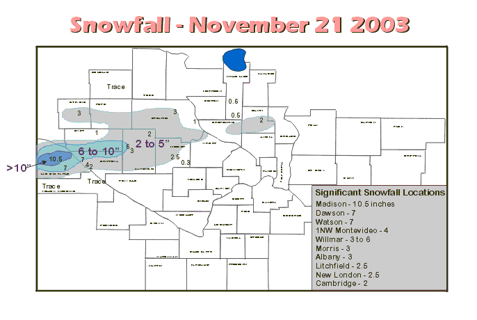
Map of November 21, 2003 snow event from the Chanhassen National Weather Service.
The main event began as very light snow on the 22nd and picked up in earnest during the night and early morning hours of the 23rd. The low pressure area moved a little faster and was a little weaker than expected, but still dropped some heavy snow amounts. A wide band of 4 inches or more fell over a large area of Minnesota. There were some exceptions. Northwestern Minnesota was too far from the storm and only saw flurries. Over southeast Minnesota warm air kept the precipitation as mainly rain. Some icy accumulation was noted in spots over southeastern Minnesota. The heaviest snow was over north central and northeast Minnesota with 13 inches at Pokegama Dam, McGregor and Brainerd.
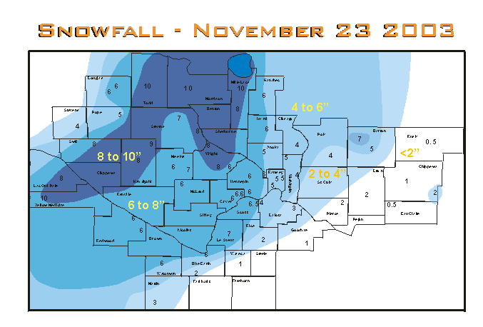
Map of November 22-23, 2003 snow event from the Chanhassen National Weather Service.
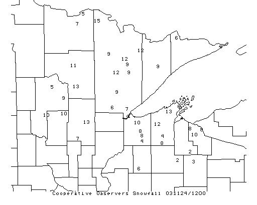
Map of November 22-23, 2003 snow event from the Duluth National Weather Service.
Listed below is information on the snow from the various National Weather Service Offices serving Minnesota
####################################################
# SNOWFALL REPORTS ARE APPROXIMATE ENDING MONDAY   #
#   MORNING - NOVEMBER 24TH.                       #
#                                                  #
# SNOWFALL REPORTS ARE FROM BOTH COOPERATIVE       #
#   AND SNOWFALL SPOTTERS                          #
####################################################

NORTHEAST MINNESOTA LOCATIONS
=============================================
 COOK                    031124/1200            9.00
 DULUTH_WFO              031124/1200            9.00
 EMBARRASS               031124/1200            9.00
 LEECH_LAKE_DAM          031124/1200            5.00
 GRAND_PORTAGE           031124/1200            4.00
 GULL_LAKE               031124/1200            4.00
 GRAND_MARAIS            031124/1200            6.00
 INTERNATIONAL_FALLS     031124/1200            5.00
 ISABELLA                031124/1200            9.00
 ISLE                    031124/1200            7.00
 LITTLEFORK              031124/1200            7.00
 MARCELL                 031124/1200           11.00
 POKEGAMA_LAKE           031124/1200           13.00
 TOWER                   031124/1200           12.00
 KABETOGAMA              031124/1200           15.00
 BABBITT                 031124/1200            9.00
 McGREGOR                031124/1200           13.00
 CLOQUET                 031124/1200            9.00
 LONGVILLE               031124/1200           11.00
 PINE_RIVER              031124/1200           10.00
 REMER                   031124/1200            9.00
 GRAND_MARAIS            031124/1200            8.00
 GRAND_MARAIS            031124/1200           10.00
 BRAINERD                031124/1200           13.00
 EMILY                   031124/1200           10.00
 BEAVER_BAY              031124/1200            3.00
 BROOKSTON               031124/1200            6.00
 COTTON                  031124/1200            9.00
 ELY                     031124/1200           12.00
 HOYT_LAKES              031124/1200            9.00
 VIRGINIA                031124/1200           12.00


PNSMSP
PUBLIC INFORMATION STATEMENT
NATIONAL WEATHER SERVICE TWIN CITIES/CHANHASSEN MN
230 PM CST MON NOV 24 2003

...TOTAL SNOWFALL FOR THE NOVEMBER 22-23, 2003 STORM...
LOCATION            STORM TOTAL
MINNESOTA...
CANBY...............10.0
LITTLE FALLS........10.0
MILAN...............10.0
LONG PRAIRIE........10.0
NEW LONDON.......... 9.0
ONAMIA.............. 8.0
CLEARWATER.......... 8.0
BENSON.............. 8.0
DAWSON.............. 8.0
ST. CLOUD........... 8.0
BUFFALO............. 8.0
WILLMAR............. 8.0
LE CENTER........... 7.0
SAVAGE.............. 7.0
ALBANY.............. 7.0
CHANHASSEN NWS...... 6.6
LITCHFIELD.......... 6.0
DASSEL.............. 6.0
REDWOOD FALLS....... 6.0
ST. JAMES........... 6.0
CAMBRIDGE........... 6.0
MORA................ 6.0
HUTCHINSON.......... 6.0
CARLOS.............. 6.0
MILACA.............. 6.0
OLIVIA...............6.0
GLENWOOD............ 5.0
CEDAR............... 5.0
MORRIS.............. 4.0
MANKATO............. 4.0
CENTER CITY......... 4.0
ST. PAUL............ 4.0
STILLWATER.......... 4.0
FOREST LAKE......... 4.0
VERMILLION.......... 3.0
FAIRMONT............ 3.0
NEW ULM............. 2.0
FARIBAULT........... 2.0


PUBLIC INFORMATION STATEMENT
NATIONAL WEATHER SERVICE LA CROSSE WI
912 AM CST MON NOV 24 2003

24 HOUR SNOWFALL TOTALS AND TOTAL SNOWDEPTH ACROSS THE AREA

LOCATION                   COUNTY              SNOWFALL   SNOWDEPTH

ALTURA 5W                  WINONA                  T           0
DODGE CENTER 2W            DODGE                  0.5
ELGIN 2SSW                 OLMSTED                0.5          1
GRAND MEADOW               MOWER                  1.0          1
LAKE CITY COOP             WABASHA                1.3          1
PRESTON                    FILLMORE               0.2
ROCHESTER AP               OLMSTED                0.3          0
RUSHFORD                   FILLMORE               0.0          0
SPRING GROVE 4N            HOUSTON                0.4
WABASHA                    WABASHA                0.1

PUBLIC INFORMATION STATEMENT
NATIONAL WEATHER SERVICE SIOUX FALLS SD
1047 AM CDT MON NOV 24 2003

24 HOUR SNOWFALL DATA IN INCHES FOR SOUTH DAKOTA AND THE
SURROUNDING STATES...ENDING 7 AM MONDAY NOVEMBER 24 2003.

MINNESOTA:

LAKEFIELD                         2.1

 Return to Minnesota Climatology Working Group Main page
URL: http://climate.umn.edu/doc/journal/snow031121_23.htm
Last modified: November 25, 2003
|