|
Heavy Snowstorm of March 14-15, 2002
Winter appears to be trying to make up for lost ground this season with some vigorous
snowstorms. This latest storm dumped heavy snowfall across much of central Minnesota. The
snow began on the morning of the 14th in southern Minnesota, with a heavy band of snow
lifting north and stalling out from St. Cloud to Alexandria.
Sleet and freezing rain mixed with the snow in the Twin Cities during the afternoon. Some thunder
and lightning was also observed with the snow on the evening of the 14th on the east side of the Twin Cities.
The snow tapered off in the early morning hours of the 15th. The heaviest snow fell from Canby to St. Cloud and Willmar,
then east to northwest Wisconsin. Some of the totals include 20.0 inches at Askov in Pine County, 17.5 inches at
St. Cloud and 10.8 inches at Chanhassen, the official snow measuring spot for the Twin
Cities. Chanhassen received 9 inches of snowfall on the 14th and that set a record for the
most snow on that date for the Twin Cities. The previous record was 7.2 set back in 1989.
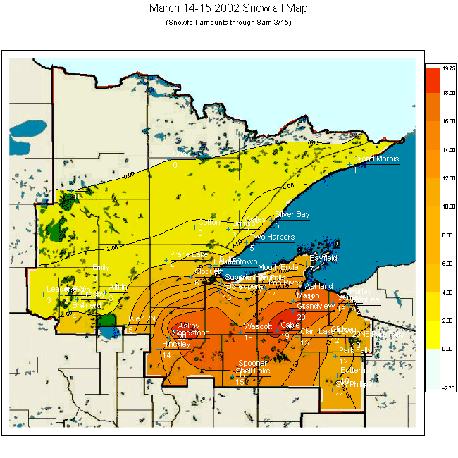
The Duluth National Weather Service assembled a snowfall map of the area.
Listed here are some Public Information Statements from the National Weather Service
regarding snowfall from this storm.
PUBLIC INFORMATION STATEMENT
NATIONAL WEATHER SERVICE TWIN CITIES/CHANHASSEN MN
700 AM CST FRI MAR 15 2002

...HERE ARE SOME TOTAL SNOWFALL REPORTS AS OF 6 AM ON THE 15TH...

TOWN                 COUNTY         SNOWFALL IN INCHES
ST CLOUD SOUTHEAST   STEARNS        17.5
WILLMAR              KANDIYOHI      17.5
MADISON              LAC QUI PARLE  13.0
WACONIA              CARVER         11.0
CHANHASSEN           CARVER         10.8  (NATIONAL WEATHER SERVICE )
EDEN PRAIRIE         HENNEPIN       10.0
STILLWATER           WASHINGTON      9.0
BURNSVILLE           DAKOTA          7.0
LONG PRAIRIE         TODD            6.0
MANKATO              BLUE EARTH      1.5


PUBLIC INFORMATION STATEMENT
NATIONAL WEATHER SERVICE TWIN CITIES/CHANHASSEN MN

SNOWFALL AMOUNTS FOR THE LAST 24 TO 36 HOURS AROUND CENTRAL AND SOUTHERN MINNESOTA AND WEST CENTRAL WISCONSIN...


14 AND 15 MARCH 2002.

LONG PRAIRIE MN    6.0
BENSON MN         15.0
MORRIS MN          4.0
LITCHFIELD MN     15.0
MILACA MN         11.0
LITTLE FALLS MN   10.0
ST PETER MN        3.0
GLENWOOD MN        9.0
REDWOOD FALLS MN  12.0
OLIVIA MN         17.0
FARIBAULT MN       2.0
SHAKOPEE MN        8.0
GAYLORD MN        11.0
WASECA MN          0.5
OWATONNA MN        T
BLUE EARTH MN      T
GARDEN CITY MN     1.0
MORA MN           18.0
FOLEY MN          16.0
HUTCHINSON MN     15.0
CAMBRIDGE MN      14.0
FARMINGTON MN      5.0
CUMBERLAND WI     10.0
CHIPPEWA FALLS WI  4.0
CEDAR FALLS WI     4.0
DURAND WI          1.0
ELSWORTH WI        8.0
HUDSON WI          6.0
ST CLOUD MN       11.5
WILLMAR MN        17.5
ELK RIVER MN      10.0
CANBY MN          16.0
ALEXANDRIA MN      5.0
BIG FALLS WI       8.0
COKATO MN         14.5
WATERTOWN MN       9.0
FARIBAULT MN       2.0
EAU CLAIRE WI      3.5
FOREST LAKE MN     5.5
GRANITE FALLS MN  13.0
JIM FALLS WI       4.6
MADISON MN        13.0
MANKATO MN         1.5
NEW LONDON MN     15.0
SAVAGE MN          8.0
SPRING VALLEY WI   5.0
SPRINGFIELD MN     6.0
STANLEY WI         3.7
STILLWATER MN      9.0
VESTA MN          12.0
WEYERHAUSER WI     8.0
ZUMBROTA MN        0.5
DAWSON MN         21.0


PUBLIC INFORMATION STATEMENT
NATIONAL WEATHER SERVICE DULUTH MN
817 AM CST FRI MAR 15 2002

THE FOLLOWING ARE SNOWFALL REPORTS CALLED IN BY SPOTTERS AND LAW
ENFORCEMENT CENTERS FOR NORTHEAST MINNESOTA AND NORTHWEST WISCONSIN
AS OF 800 AM THIS MORNING.

                              TODAYS
      NORTHEAST MINNESOTA    SNOWFALL/STORM TOTAL/SNOW DEPTH/ LAST
                              INCHES    INCHES      INCHES   REPORT
NWS DULUTH....................       /    4.7    /   13    /   9AM
HERMANTOWN....................       /    7.0    /         / 730AM
BRAINERD LEC..................       /    4.0    /         / 730AM
TWO HARBORS 7NW...............       /    4.8    /   19    / 630AM
COTTON........................       /    2.5    /   12    /   7AM
AITKIN 20N....................       /    2.5    /         / 730AM
NISSWA 3NE....................       /    2.5    /         / 730AM
CONGDON.......................       /    5.5    /         / 730AM
SILVER BAY....................       /    4.5    /   18    /   7AM
ASKOV.........................       /   20.0    /         /   7AM
FINLAYSON/SANDSTONE...........       /   13.5    /         /   6AM
CROSBY 5N.....................       /    3.5    /         / 630AM
MARBLE LAKE...................       /    3.5    /   28    / 630AM
CLOQUET.......................       /    6.0    /   24    /   6AM
BRIMSON.......................       /    2.5    /   15    / 530AM
WALES 2E......................       /    2.0    /   25    / 730AM
PRARIE LAKE...................       /    3.5    /         / 730AM
GRAND MARAIS 13W..............       /    0.5    /   14    /   8AM
ISLE 12N......................       /    5.3    /   13    /   8AM

                              TODAYS
      NORTHWEST WISCONSIN    SNOWFALL/STORM TOTAL/SNOW DEPTH
                              INCHES    INCHES      INCHES

SUPERIOR......................       /     6.0   /   20    / 630AM
GURNEY........................       /    18.0   /   38    /   8AM
PARK FALLS 20NE...............       /    10.0   /         /   8AM
CABLE.........................       /    19.0   /   37    / 730AM
PARK FALLS....................       /    11.7   /         / 730AM
MONTREAL......................       /    12.0   /   38    / 730AM
GLIDDEN.......................       /    12.0   /   30    /   7AM
SUPERIOR 10S..................       /    15.0   /   30    /   6AM
GRANDVIEW.....................       /    20.0   /         /   7AM
WASCOTT.......................       /    16.0   /         /   7AM
10SW CLAM LAKE................       /    15.0   /         /   7AM
MASON.........................       /    14.5   /   31    / 630AM
AMNICON RIVER VALLEY..........       /     7.0   /   19    /   7AM
BUTTERNUT.....................       /    10.0   /   23    /   6AM
BAYFIELD 6N...................       /     7.0   /   22    /   7AM
ASHLAND.......................       /    18.0   /         / 530AM
MOUTH OF THE BRULE... ........       /     8.0   /         /   6AM
BRULE.........................       /     7.0   /         / 730AM
SPOONER.......................       /    16.5   /   24    /   7AM
SHELL LAKE 3W.................       /    15.0   /         / 730AM

 Return to Minnesota Climatology Working Group Main page
mcwg@soils.umn.edu
URL: http://climate.umn.edu/doc/journal/snowstorm020314.htm
Last modified: March 15, 2002
|