Dry Summer 2006 - Situation Report (July 11, 2006)

Weak northwesterly flow in the upper atmosphere since early May has led to often-comfortable temperatures and
very few severe weather episodes. Inactive weather also means dry weather. When this persistent weather pattern has
produced rain events at all, they have occurred in the form of geographically isolated, short-lived showers and
thunderstorms. Streaks of precipitation dampened some of the landscape, but most locales were effectively missed
over the last eight weeks.
The dry weather began in the middle of May, continued through June (historically Minnesota's wettest month), and on into
early July. Rainfall totals were well below average across much of Minnesota from mid-May to mid-July 2006.
With a few exceptions across southern Minnesota and small portions of east central and northeast Minnesota there was
little substantial rain during the period. The precipitation shortfalls led to low stream flows, increased
wildfire danger, and deteriorating crop conditions.
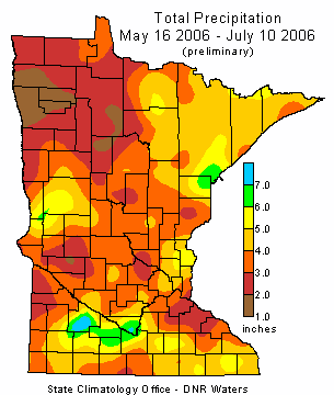
Rainfall totals for the past eight weeks were less than four inches in many counties
(see map above), and less than two inches in some areas.
Eight week rainfall totals deviated negatively from historical averages by more than
three inches in many areas (see map at lower left). Rainfall
deficits exceeded four inches in portions of northwest, central, and southeast Minnesota.
When compared with other May 16 to July 10 rainfall totals in the historical database, this year's
rainfall totals for the period rank among the lowest on record in some locales. The situation is
especially notable in northwest Minnesota where near-record low precipitation totals are common
across a multi-county area.
(see map at lower right).
|